Research ProjectsStructural | Planetary | Geomechanics
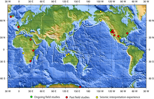
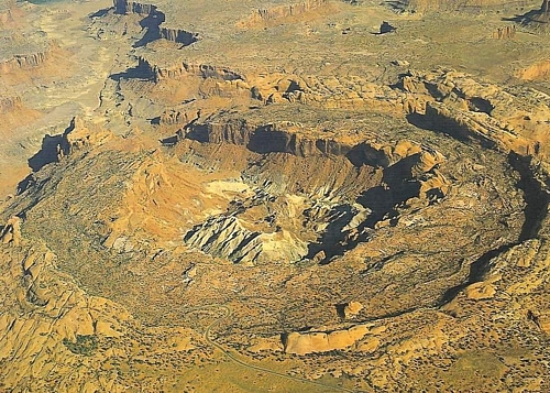
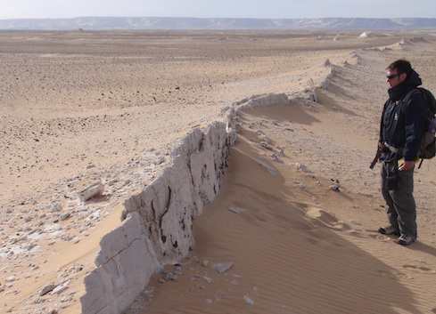
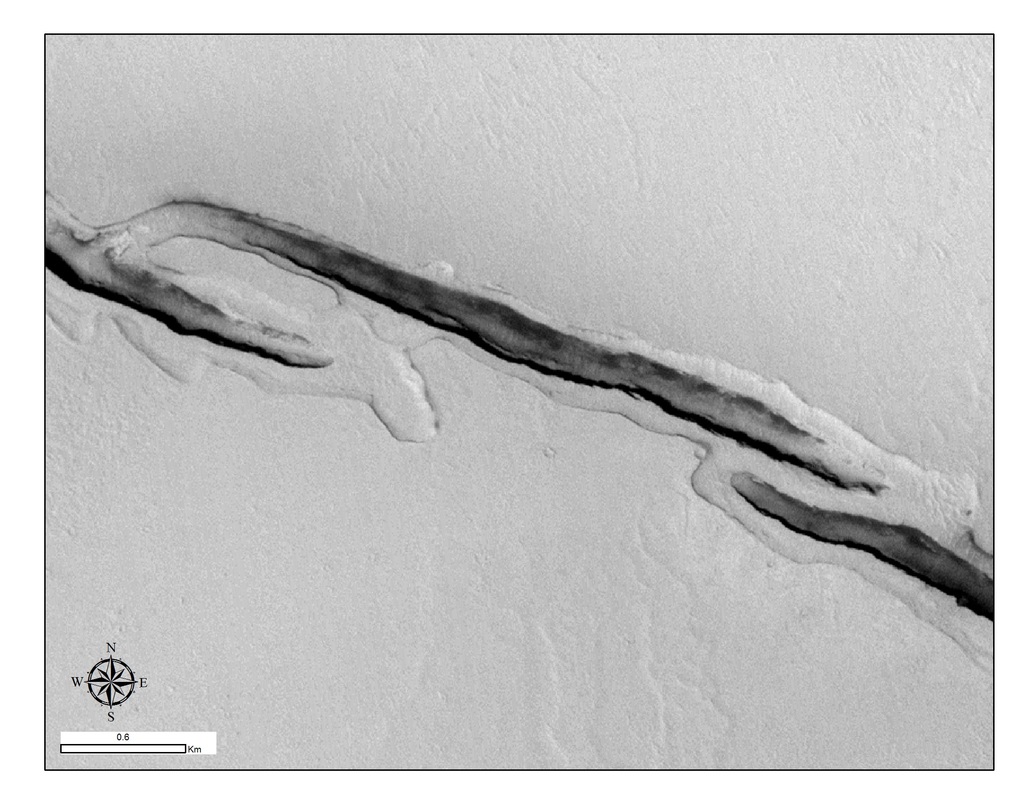
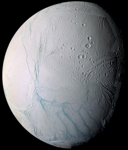
I have been involved in numerous projects, both on Earth and other planets and moons in the solar system. The map on the right shows the location of past and current field-based projects. Continental Rifting in East Africa Continental breakup is the precursor to ultimate plate separation and seafloor spreading at midocean-ridge systems. However, the fundamental processes by which thick continental lithosphere is broken, thinned, and ultimately split apart are enigmatic. It is known that magma plays an important role during the transition to seafloor spreading; however, the role of magma early in the continental rifting process is unclear. Past work suggests that plate tectonic stresses alone are insufficient to account for the rifting of continental lithosphere, and that magma must therefore be an active player in the continental rifting process, as opposed to a passive response. We are examining the process of continental rifting in a youthful rift system (<7 Myr old) in order to determine the relative contributions of magmatic and tectonic processes. This work also examines the progressive evolution of fault systems as activity migrates away from the dominant border faults into the rift center with ongoing extension, as well as the evolution of magmatic centers, volumes, and strain through time. We focus on the Natron rift basin of northern Tanzania and the Magadi rift basin of southern Kenya. These basins are also important for understanding the evolution of modern hominids, as early rifting processes affected the environments in which early humans lived. Funding Agency: NSF. Past Graduate Students: James Muirhead; Matt Blakeslee. Collaborators: Cindy Ebinger (University of Rochester); Tobias Fischer (University of New Mexico). Plate Boundary Evolution in Iceland Iceland is the manifestation of where the North American and Eurasian plates are rifting apart. Huge faults and fissures have ripped open the surface, often associated with major earthquakes and basaltic volcanism. This is a dynamic and exciting place to learn about the fault evolutionary process at an obliquely-spreading plate boundary, and to unravel the link between plate motions, faulting, earthquakes, and volcanism. My work has unraveled the pattern of, and variability in, fault development on the Reykjanes Peninsula in southwestern Iceland, particularly in terms of how the style of faulting oscillates through time in response to repeated episodes of magmatic and volcanic activity. Funding Agency: NSF. Past Graduate Students: James Grant; Leslie Fernandes; Nate Boersma; Jane Barnes. Collaborators: Amy Clifton (formerly at University of Iceland). Evolution of the Hat Creek Fault, California Although far northern California is not highly populated, earthquake risks do exist due to a number of active normal faults in the region of Lassen Peak volcano. A major player in this regard is the Hat Creek fault, which shows evidence of significant activity over the past million years, creating up to 350-meter-high fault scarps in Tertiary basalt lava flows, and a total vertical offset of ~570 m. Since the Late Pleistocene, older scarps were abandoned and active scarps developed in their hanging walls, cutting through 24,000-year-old basalts (the Hat Creek basalts). The slip rate on the fault is estimated to be as high as 3.6 mm/yr. Nonetheless, the timing of the most recent earthquake along the fault and the potential for future earthquakes is unclear. We estimate that the Hat Creek fault is capable of at least M6.7 earthquakes with a frequency of every 667±167 yrs. Its complex geometry, consisting of three sets of segmented fault scarps with variable orientations, reflects ~45º of clockwise rotation in the regional stress field over the past 1 Myr. Past Graduate Students: Erin Walker; Nicole Bellino (undergrad); Matt Blakeslee. Collaborators: Bob Krantz (ConocoPhillips); Marie Jackson (University of California, Berkeley). Formation of Upheaval Dome, Utah The creation of Upheaval Dome, Canyonlands National Park, Utah, has long confounded geologists. This giant circular hole in the Utah desert is actually a structural dome with an eroded center caused by weaker, older rocks at the center of the dome. It has long been debated whether the dome represents the long-term effects of salt diapirism in the Paradox Basin or a meteorite impact scar. Recent work seems to support the meteorite impact hypothesis. Our work suggests that Upheaval Dome represents the end-result of a long history of deformation that was triggered by a meteorite impact but subsequently evolved as salt diapirism continued below the original impact site. Our detailed field mapping of structural features as well as thin-section petrographic work helped us unravel the mechanics of disparate deformation styles present in the rock units around the dome. Past Graduate Students: Rachel Daly. Polygonal faulting in the Western Desert, Egypt Polygonal faults are enigmatic in that multiple fault orientations are able to form contemporaneously. Such fault types have been described in overburden rocks of producing oilfields and commonly exist below the sea floor, making them inaccessible. Some have been interpreted to be the result of large scale mass wasting (underwater landslides); however, this process cannot form homogeneous polygonal shapes, as is commonly observed. Rather, the faults likely form under conditions of isotropic horizontal extension, similar to the phenomenon of orthorhombic faulting. We studied rare on-land exposures of polygonal faults in the Western Desert of Egypt, near Farafra Oasis. These faults in Cretaceous chalks are pervasively dilated and vein-filled, indicating the important role of high fluid pressures during faulting, presumably during burial and diagenesis. Our work is part of a research consortium (Desert Eyes) coordinated through Hamilton College and Missouri University of Science and Technology, also involving the University of Idaho, University of Vermont, and Egyptian universities in Alexandria, Asyut, Damanhour, Sohag, and Aswan. Funding Agency: NSF. Past Students: Eric Doubet (undergrad). Collaborator: Barbara Tewksbury (Hamilton College). Plate tectonics and ice deformation on Europa Europa has a relatively thin (<30 km) and intensely fractured crust of ice around an underlying ~100-km-thick ocean. These fractures include a multitude of extensional features such as cracks, cycloids, ridges, dilational bands, and normal faults. We also see evidence of strike-slip faults and features related to zones of contraction. We have been exploring the nature and origin of the stress fields that produced these faults and fractures. Much of the deformation is related to the tidal distortion of the ice shell above the underlying ocean, including effects of long-term faster-than-synchronous rotation of the ice shell relative to the Europa's solid core. Recently (in a 2014 article in Nature Geoscience), we described evidence that older, missing portions of Europa's geologically young surface may have been recycled into the ice shell interior along subduction zones, suggesting that Europa may be the only other body in the solar system other than Earth to exhibit the process of plate tectonics. Funding Agency: NASA. Past Graduate Students: Sandi Billings; Scott Marshall; Justin Vetter; Julie Groenleer; Christina Coulter; Jonathan Kay, Charlie Detelich, Robin Van Auken, Walter Zimmerman. Collaborators: Louise Prockter (Applied Physics Laboratory, Johns Hopkins University); Terry Hurford (NASA Goddard); Michael Watkeys and Lauren Hoyer (University of KwaZulu-Natal, South Africa); Catherine Cooper (Washington State University); Geoffrey Collins (Wheaton College); Alyssa Rhoden (Arizona State University). Fissure Eruptions, Faults, and Water on Mars Mars rovers have found evidence that the surface of Mars was once very wet. Recent observations suggest that liquid salty water may occasionally flow across the surface of Mars today. The big question now is, what happened to all the water that used to be present on the surface? Hydrogen signatures on Mars have been suggested to represent a proxy for subsurface moisture, particularly in the polar regions. However, we have discovered an interesting relationship between hydrogen signatures in the equatorial region of Mars and the local topography, suggesting that ancient faulted highlands may be controlling moisture distribution in some manner. We have also studied the sites of geologically recent eruptive fissures that show evidence of lava flows from the fissures as well as megafloods into large drainage valleys, suggesting that magma interacted with subsurface ice and created large volumes of water that flowed across, and modified, the surface. These fissures may even host local hydrothermal flow systems and ground seeps that could offer potential habitable environments. Funding Agency: NASA. Past Graduate Students: Jon Meyer (undergrad); June Clevy; Amy McMillin; Matthew Pendleton. Postdoctoral Researcher: Amanda Nahm. Collaborator: Devon Burr (University of Tennessee-Knoxville). Tectonics and a Global Ocean on Enceladus NASA's current Cassini spacecraft mission to the Saturnian system is revealing a wealth of insight into the diversity and splendor of Saturn's major moons. Similar to Europa, the surface of Enceladus is comprised of water ice that is pervasively fractured. Our recent work (published in Geophysical Research Letters in 2011) revealed that Enceladus likely has a global, tidally-responding, subsurface ocean that drives much of the surface fracturing and the geyser-like eruption of plumes of water ice from the "Tiger Stripes" in the south polar region. More recent spacecraft measurements have confirmed that a global ocean is likely to exist. Nonetheless, the pattern of fracturing is very spatially heterogeneous on Enceladus. Some portions of the surface have been pervasively tectonized whereas others show only ancient cratered terrains that have only recently started to be dissected by fractures called pit chains. These pit chains show a pattern of orientations that suggest they formed in response to the faster-than-synchronous rotation of an outer ice shell above and underlying ocean, similar to Europa. Funding Agency: NASA. Past Graduate Students: Alex Patthoff; Emily Martin; Tony Gallagher; Marques Miller (undergrad). Postdoctoral Researcher: Amanda Nahm. Collaborator: Catherine Cooper (Washington State University). Tectonic Mountains on Titan Titan is the second-largest moon in the solar system (after Ganymede) and the largest in the Saturn system. Its thick nitrogen-rich atmosphere veils an icy surface composed of frozen methane and ethane, as well as evidence of liquid methane lakes, surface drainages, and equatorial sand dunes. Titan is also dotted with linear mountain belts that attest to the effects of tectonic processes that likely result in fault-induced uplifts. The type of faults involved and the causes of the deformation are unknown. However, we have found that the stress fields that would be produced in response to the effects of spin-rate changes on Titan during periods of global expansion or contraction are consistent with the global orientations of these linear mountains, especially if the thickness of Titan's ice shell is thinner at the poles than at the equator. Funding Agency: NASA. Past Graduate Students: Casey Cook-Hallett (UI Physics student). Collaborators: Jason Barnes (University of Idaho); Jani Radebaugh (Brigham Young University). Fracturing and Flexure on Dione Dione is another enigmatic moon in the Saturn system. It is much bigger than Enceladus but it is unclear if it contains a liquid ocean beneath its ice shell. The surface is pervasively fractured; however, the fractures seem to arrange into localized rift zones. Some of the exposed fault surfaces are very bright, leading to the question of whether or not Dione may still be tectonically active. Flexure alongside prominent ridges on Dione suggest an ancient elastic thickness of only ~3.5 km, which would require heat fluxes that could be produced by tidal heating, but only if a global ocean were present in the geologic past. The ongoing presence of such an ocean is currently unknown, but if present, it may bode well for ongoing tectonic activity on Dione. Funding Agency: NASA. Past Graduate Student: Emily Martin. Evolution of the Lake Mead Fault System, Nevada The Lake Mead fault system in southern Nevada marks a region of strike-slip tectonics in a transitional environment along the margin of the Basin and Range extensional province. A complex interaction between the NE-SW striking Lake Mead fault system and the NW-SE striking Las Vegas shear zone has resulted in interesting growth patterns in the respective fault systems as they mechanically interacted and linked together. Fault patterns imply normal faults formed as secondary deformation features at the tips of strike-slip fault segments that ultimately facilitated linkages between mutually adjacent fault segments. Past Graduate Student: Scott Marshall. Collaborators: Scott Marshall (Appalachian State University); Michele Cooke (University of Massachusetts-Amherst). Fracture Evolution in Basalt Lava Flows, Idaho The fracture patterns that form within cooling lava flows present a problem that geologists have been studying for over 300 years, with new insights still waiting to be discovered. Our work considered the variability of fracture styles in lava flows with different thicknesses and different shapes with the help of thermo-mechanical numerical models. We also investigated the importance of inflationary processes during lava cooling. Understanding of the fracture process in cooling lavas tell us about the permeability of fractured basalts, and how might this be important for groundwater flow or the migration of contaminants into the subsurface. Funding Agency: DOE. Past Graduate Student: Conrad Schaefer. Sill Intrusion in Antarctica In perhaps the most unspoiled expanse of land on the planet, at the Dry Valleys of Antarctica, 15 million years of wind erosion in an unglaciated system of valleys has preserved some of the best exposures of igneous sills on Earth. These massive bodies of dolerite, exceeding 300 m thick, were intruded as enormous pools of magma, several kilometers below the surface of mid-Jurassic Earth, at the time of the initial stages of breakup of the supercontinent, Gondwana. The geometries that the sills make in the exposed valley walls provide important clues to the workings of the plumbing system of a major magma body. Rarely are we afforded such incredible insights into how a magma system develops at these depths in the crust. The specific geometries and patterns of sills allowed me to make inferences about the intrusion mechanics, including the possible magma flow directions in the subsurface. Funding Agency: NSF. |
Field areas
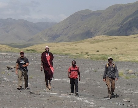
Field crew in the Natron valley, Tanzania
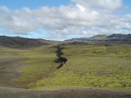
Normal fault near Krisuvik, Iceland
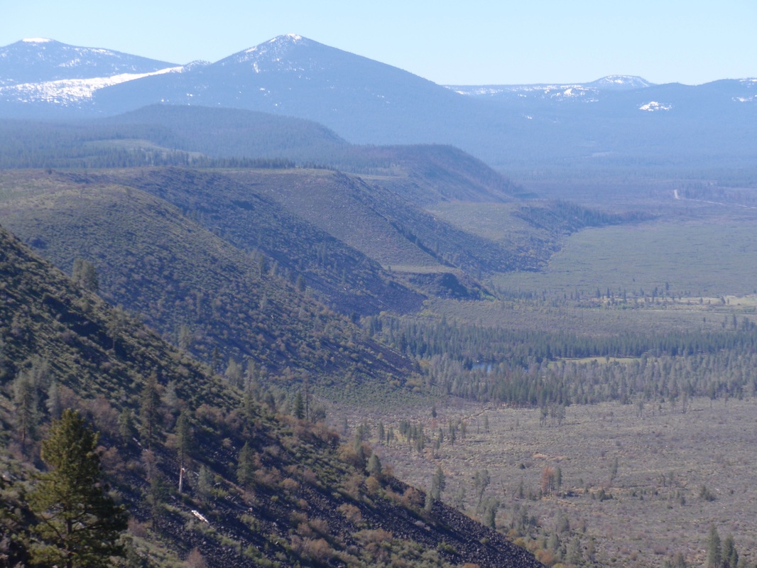
The Hat Creek fault scarp
Upheaval Dome impact site, Utah
Polygonal fault outcrop, Egypt
The fractured ice shell of Europa
Eruptive fissures and melt-rings, Cerberus Fossae, Mars
Tectonic fractures on Enceladus
AVIATR concept mission on Titan
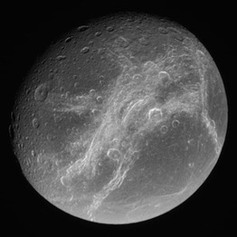
Bright rift zones in the ice shell of Dione
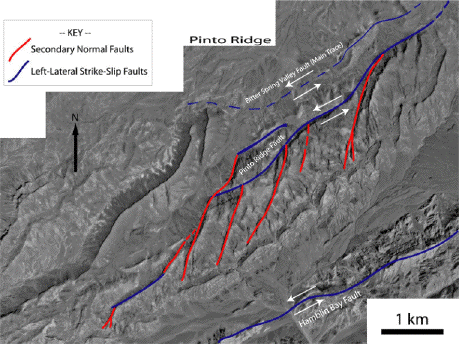
Interpreted faults at Lake Mead, Nevada
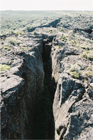
Inflation fissure in lavas, Snake River Plain, Idaho
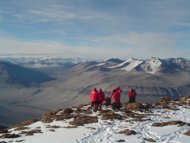
Field work in the Dry Valleys, Antarctica
|
